REAL-TIME, CONSTRUCT TO DESIGN SOLUTION The GML – together with its Construct-to-Design Module – is a high-speed computing and rapid- visualisation technology, proven to significantly improve the efficiency and quality control of tunnel construction. Used during various stages of the construction cycle, the system tracks and verifies as-built construction against the desired design in real-time. […]
READ MOREGMS-Dual
Long-Term, Background, Prism and Prismless Solution The GMS-Dual (Geotech Monitoring Station) is a long-term, background monitoring tool designed to track and monitor both prisms and virtual points. The system allows for measurement of areas that are difficult, dangerous or even impossible to reach using prisms. It specialises in monitoring open cut pits and highly vegetated […]
READ MOREGMS-Prism
Long-Term, Background Prism Solution The GMS-Prism (Geotech Monitoring Station) is designed as a long-term, background monitoring tool. Highly accurate, the system tracks and monitors prisms installed on the area of interest. It specialises in monitoring open-cut pits and highly vegetated slopes, and detecting and measuring deformation on tailings dams, dumps and cuttings. Whether choosing the […]
READ MORESSR-Agilis
TACTICAL, HIGHLY-MOBILE SOLUTION The SSR-Agilis is a standalone vehicle monitoring system designed to protect personnel and valuable equipment in active working areas of a mine site. A complete safety-critical solution that transmits visual and audible warnings to operational crews in real time, the SSR-Agilis ensures continued operations without interruption or incident.
READ MOREMonitorIQ
Designed and developed by geotechnical engineers for geotechnical engineers, MonitorIQ is a single-dashboard data aggregation software that gathers and visualises all information from on-site sensors, ensuring users spend less time collecting data and more time analysing data. Through the centralisation of all monitoring data into one dashboard, users are presented with intuitive side-by-side analysis and […]
READ MORESSR-OMNI
FULL-COVERAGE, HIGH-RESOLUTION SOLUTION Designed to detect hotspots of movement in an ultra-fast, all-encompassing scan, the SSR-Omni covers the broadest of areas with the highest resolution. A rotational Real Aperture Radar (RAR), it provides unique, real aperture measurements that are less susceptible to contamination, yet delivers millions of pixels. It monitors 360° through a thin vertical […]
READ MORESSR-SARx
HIGH RESOLUTION, LONG-RANGE SOLUTION Designed to detect new risks and hazards, the SSR-SARx monitors areas from long ranges with the highest resolution. A 2D Synthetic Aperture Radar, the SSR-SARx effectively images walls, forming high resolution targets coupled with a longer integration time, aiming to pick up small movements that occur over many months.
READ MORESSR-FX
STRATEGIC, BROAD-AREA SOLUTION Designed to detect new risks and hazards, the SSR-FX covers vast mine areas for longer periods to provide geotechnical peace of mind.
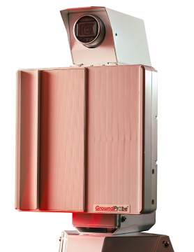
 A 2D Real Aperture Radar, the SSR-FX monitors broad areas through a thin vertical stripe that quickly sweeps around the wall of the mine site, left to right, detecting hotspots […]
READ MORESSR-XT
TACTICAL, TARGETED SOLUTION Designed to critically monitor known movements that pose a potential or immediate threat to the safety or productivity of mining operations, the SSR-XT monitors slope movements within a targeted area. A 3D Real Aperture Radar, its fine pencil beam scans in a raster pattern to provide full 3D imaging, guaranteeing every targeted […]
READ MORE