
Successful Monitoring and TARP at Ernest Henry Mine
SUCCESSFUL MONITORING AND TARP NEW
OVERVIEW
Owned by Xstrata PLC, Ernest Henry Copper-Gold Mine is situated 131 kilometers northeast of Mount Isa, Queensland, Australia.
The mine is 1,500 metres in length by 1,200 metres wide with a final depth in excess of 500 metres, producing both copper and gold, with a 11 megatonnes per annum capacity.
Safety is the primary concern at the site. With 450 people employed on-site there are a significant number of both employees and contractors working in the pit. Considering the pits challenges, evacuations and production interruptions are highly likely events.
As a result of the aggressiveness of the original design of the mine, there was a high potential for planar, wedge and toppling failures. The mine structural domains, steep walls and two aquifers contribute to high pore pressures.
CHALLENGE
To ensure continued mine safety, GroundProbe was challenged with providing a solution for monitoring the different stages of mining, rapid scanning of the high-risk areas, and broad-area screening of the pit.
In 2009, a 600,000-tonne rock collapse was successfully recorded and managed with the new Trigger Action Response Plan (TARP). Personnel and equipment were evacuated before the failure and exclusion zones were demarcated.
SOLUTION
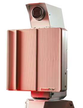
GroundProbe immediately recommended the installation of SSR-X (a precursor to SSR-XT).
Complimenting the advanced hardware offering, GroundProbe’s intuitive visualisation software SSR-Viewer. SSR-Viewer allowed the geotechnical team to begin collecting data daily to pinpoint movement hotspots. The complex data was visually represented via a colour gradient heatmap draped over a photographic representation of the area, making the data more easily reportable.
RESULTS
As a result of the monitoring, mining was uninterrupted and TARP’s were adjusted for post-failure monitoring. There were some minor redesigns to ‘mine off’ the failure and since then similar geotechnical conditions have been detected before failure allowing accurate predictions for the future.
Mine safety concerns have now been addressed with the continual monitoring of slope movements using the Slope Stability Radar (SSR™) system, reducing the interruptions to production and increasing revenue.
“SSR is the preferred method for wall displacement monitoring at Ernest Henry Mine (EHM), with proven effectiveness in mitigating risk associated with slope scale rock mass failure.”
– Peter Saunders, Geotechnical Superintendent, Xstrata’s Ernest Henry Mine.
EHM has been utilising the SSR System since May 2008, immediately recording two main areas of concern. These areas have potential failure in tonnes of 1,000,000 and 400,000, respectively. With the recorded data, they have implemented TARP to deal with accelerated deformation detected by the SSR System.
The SSR System communicates to the Primary Monitoring Point through radio ELink via mesh network to the dispatch hut.
At the time, EHM leased two SSR Systems, one for continuous monitoring of longer distances at the top of the pit and the other for critical monitoring of shorter distances lower in the pit.
Said Peter Saunders:
“As a company, we feel privileged to have the safety reassurance of having SSRs scanning our primary activity areas.”
Two Radars are Better than One
EHM’s policies state SSR units are required for:
• Monitoring of different stages of mining
• Rapid scanning of high-risk areas (Hazard Management Approach)
• Broad area scanning of the pit (Proactive Hazard Identification).
The SSR has become a permanent feature embedded in the body of the open-cut pit, so much so that a dedicated concrete pad has been built for it, ensuring solid ground and stability for scanning.
Numerous small-scale failures have been predicted, monitored, and managed with the SSR range, precision information, and SSR analysis tools.
In addition to the small-scale failures, several significant slope failures have occurred that the SSR’s were monitoring. The SSR’s provided the data and tools needed to coordinate a safe and efficient evacuation of personnel and equipment and ensured that production impacts were kept to an absolute minimum.
Slope instability management, safer working environments and advanced alarming tools have enabled Ernest Henry Mine to strengthen their ‘No Harm’ policy and manage risks better than ever. Decisions to halt production and general mine activities are now calculated using information derived from the SSR.
GroundProbe is proud to have shared their world-class expertise in providing real-time solutions for measuring and monitoring geohazards to restore ongoing onsite mine safety.
GroundProbe is the most trusted brand for real-time geohazard monitoring. With a track record that speaks for itself, our fleet of cutting-edge technologies deliver the most precise and valuable data.
Media ContactJustin Brosnan |