Operational Confidence Through Continuous Monitoring: The Caserones Story

OVERVIEW
Mina Caserones is a large open-pit copper–molybdenum mine located in Chile’s Atacama Region, approximately 125 km southeast of Copiapó, at elevations between 3,200 and 5,500 metres above sea level. Operated by Lundin Mining, which acquired a 70% interest in Minera Lumina Copper Chile from JX Metals Corporation in 2023, the site is positioned near Lundin’s Candelaria Copper Mining Complex and the Josemaría project in Argentina.
The mine uses conventional truck-and-shovel methods and has a low strip ratio. Five phases remain in its life-of-mine plan. Processing facilities have been operating since 2014, producing 100,000–120,000 tonnes of copper concentrate, 1,700–2,500 tonnes of molybdenum concentrate, and around 25,000 tonnes of copper cathodes annually.
The Caserones deposit is considered to be a classic example of an Andean copper–molybdenum porphyry deposit. The basement assemblage is a Carboniferous assemblage of metavolcanic and metasedimentary rocks. This assemblage has been intruded by the Caserones Granite in the Upper Carboniferous and the El Colorado Granite in the Permo–Triassic. The regional structure is characterized by a series of rigid blocks of granitic basement that occupy anticlinal cores that formed as a result of regional scale folding of the Mesozoic supracrustal sequences.
A maximum vertical extraction of 10 benches or a maximum movement of 60 Mt ton per year is considered as a restriction for each phase. The concentrator operated at 32.1 Mt in 2024, with the ability to ramp up beyond 35 Mt by 2030 (as determined by the Company following the date of the Caserones Report). Oxide material is placed on the dump leach in the period in which that material is mined.
Bench design is driven by kinematics and stability of inter-ramps and final walls are driven by the quality of the lithologic model, the shear strength or rock mass strength as assessed using limit equilibrium. Key inputs to those analyses are the quality of the rock strength database, the rock quality database, the joint/fault strength database, the structural model (joints and faults) and the hydrogeologic model (pore pressures and dewatering).
With complex topography and geotechnical challenges, Caserones relies on real-time radar monitoring to ensure ongoing safety and operational efficiency.
CHALLENGE
With increasing mining activity along the Northwest Wall of the pit, site personnel identified a critical need for continuous monitoring, especially during edge operations and periods when wall behaviour exceeded Alert Level 2 thresholds.
The geotechnical team sought a solution to deliver reliable, high-availability radar data to inform timely, risk-based decisions in this sensitive area.
We needed a dependable, high-availability system to monitor the wall during critical operations. This was essential for both safety and operational planning.
— Juan Pizarro Alvarez, Ingeniero Geotécnico e Instrumentación, Mina Caserones.
SOLUTION
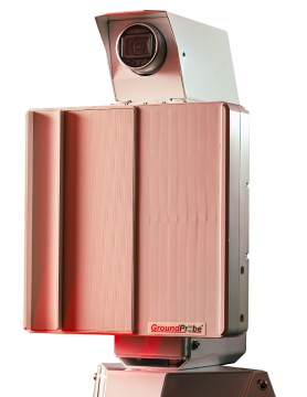
Lundin Mining engaged GroundProbe to deploy a mobile radar-based monitoring solution tailored to the mine’s geotechnical risk profile. The response included:
- SSR-XT units strategically deployed for high-precision, real-time tactical monitoring of wall movements
- Geotechnical Specialist Services (GSS) providing remote analysis, radar configuration support, and operational guidance
When wall activity surpassed predefined thresholds, the SSR-XT units enabled around-the-clock monitoring, supported by GroundProbe’s GSS experts who assisted with alarm validation and data interpretation.
GroundProbe promptly provided radar installation and monitoring services. Their support was instrumental in achieving high radar availability during critical monitoring windows.
— Juan Pizarro Alvarez, Ingeniero Geotécnico e Instrumentación, Mina Caserones.
RESULTS
The implementation of radar monitoring at Caserones delivered immediate improvements in both data reliability and responsiveness. With GSS involvement, the mine could continuously oversee slope conditions and act decisively during high-risk periods.
Radar data played a key role in reinforcing onsite observations, building confidence in decision-making, and elevating safety protocols around wall management.
We achieved strong results in terms of radar availability and data reliability, particularly during heightened risk periods.
— Juan Pizarro Alvarez, Ingeniero Geotécnico e Instrumentación, Mina Caserones.
FUTURE ACTIONS
Mina Caserones is now transitioning from SSR-XT to SSR-FX radars to improve scanning efficiency and reduce monitoring time. This marks a significant step in optimising their slope stability strategy.
Ongoing collaboration with GroundProbe remains a central part of the mine’s future plans, as they continue to refine monitoring systems, enhance operational readiness, and ensure geotechnical stability.
During the time we have been working alongside GroundProbe, we have received great support and willingness from the work team, both in terms of monitoring and equipment availability. We appreciate the ongoing concern for the quality of the work and unconditional support for our requests.
— Juan Pizarro Alvarez, Ingeniero Geotécnico e Instrumentación, Mina Caserones.
Caserones is one of the first sites that trusted in our monitoring Team in Chile, since then, we have been working close to support the geotechnical team on site to maintain the operation in high geographic and geotech challenges. It is an honour to support and being part of such amazing operation.
— Andrés Baza, Senior Geotechnical Engineer (GSS Santiago), GroundProbe.
-END-
 |
 |


