


MonitorIQ® Desktop 2023.1 – Enhanced 3D Georeferencing
MonitorIQ® Desktop 2023.1 is GroundProbe’s latest software release – delivering a software experience that is more intuitive, has fewer steps, and looks great!
MonitorIQ® Desktop 2023.1 sees functionality, usability, security, and reliability enhancements across the board, as well as new features and tools. We designed the release with the customer in mind, incorporating many new features based on direct customer feedback.
Enhanced 3D Georeferencing: Streamlined Workflow for Effortless Visualization and Analysis
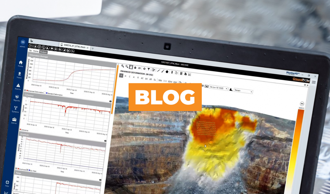
A fundamental feature improvement in MonitorIQ® Desktop 2023.1 is enhanced 3D georeferencing, ensuring clarity, precision, and crystal-clear visualisation of our co-located Digital Terrain Map (DTM) data.
ENHANCED VISUALISATION
Experience a heightened level of clarity and precision with our software’s advanced 3D visualization capabilities. By overlaying radar data onto the pit, our software provides an unprecedented understanding of mine geometry. View whole areas of interest by simply selecting polygons and squares, streamlining the selection process and improving the overall intuitive nature of our software.
SIMPLIFIED ANALYSIS
Our 3D Georeferencing software streamlines the analysis process by consolidating data selection and figure creation in a single location. With ease, detect and analyze data in 3D, empowering you to draw valuable insights efficiently. Clear, concise, and comprehensive analysis has never been easier.
IMPROVED WORKFLOW EFFICIENCY
Experience a faster and more efficient workflow with our software’s remarkable reduction in steps from 7 to 4. We understand the value of your time, and our streamlined process will save you valuable minutes, ensuring more time for critical decision-making. Additionally, our software allows you to choose multiple points, enhancing alignment between radar data and other features, and resulting in improved accuracy.
SEAMLESS INTEGRATION
Effortlessly visualize your GeoTIFFs through our software’s automatic alignment to the Digital Terrain Model (DTM). With this seamless integration, you can focus on extracting meaningful insights rather than spending time on manual alignments. Additionally, we have included high-resolution aerial photos, enabling you to identify features that may not be visible in the radar Front View.
COMPREHENSIVE PERSPECTIVE
Gain a comprehensive view of your mine with our plan view feature, allowing you to extend beyond the crest of the benches. This broader perspective empowers you to make informed decisions regarding moving areas within the mine, ensuring the safety and stability of your operations.
In conclusion, our enhanced 3D Georeferencing software offers an intuitive, streamlined workflow that enhances visualization, simplifies analysis, and improves efficiency. Embrace this innovative solution and unlock the full potential of your geohazard monitoring. Trust GroundProbe’s unmatched expertise and commitment to safety as we lead the way in delivering accurate, real-time data and unparalleled support. Make critical decisions with confidence using our enhanced 3D georeferencing.
“Our business has multiple SSR-XT across multiple sites. MonitorIQ provides me the ability to monitor all radars at all sites from one place.”
Ross Branch
Technician Geotechnical
BHP“GroundProbe’s Monitor IQ is a geotechnical analysis platform that represents an advanced slope monitoring system in mining environments. Its ability to detect, monitor and facilitate equipment analysis provides real-time information on the displacements of geotechnical structures and the physical conditions of equipment. Continuous analysis of equipment health is crucial to ensuring data reliability, enabling the adoption of preventive measures that increase the safety of mining operations and the people involved. Monitor IQ plays a fundamental role in optimizing monitoring processes in geotechnical structures, contributing significantly to operational efficiency.”
Guilherme Dutra
Engenheiro de Minas Geotecnico
Samarco
#GroundProbe #InnovateWithUs #3DGeoreferencing
WHAT DO I DO IF I HAVE OLDER SOFTWARE?
To receive the best result from our systems and ensure best-practice geotechnical monitoring, we recommend you upgrade to MonitorIQ® Desktop 2023.1 TODAY!
For more information on MonitorIQ® Desktop > CLICK HERE
Your local GroundProbe office > CLICK HERE