Unlocking the power of NISAR
How Advanced Radar Technology is Transforming Geohazard and Infrastructure Monitoring
We’re excited to share that 3vGeomatics (3vG), a key part of Orica Digital Solutions’ Geosolutions portfolio, is enhancing its ground movement monitoring service by integrating data from the NISAR NASA-ISRO SAR satellite. By leveraging NISAR’s advanced radar capabilities, we now deliver more reliable, cost-effective insights, especially in remote and vegetated areas. Here’s a closer look at the technology behind it.
How does NISAR work?
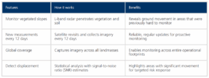
NISAR (NASA–ISRO Synthetic Aperture Radar) is the first satellite mission to use dual radar frequencies: L-band and S-band, to systematically map Earth’s surface. Its L-band radar, with a longer wavelength (~240 mm), penetrates vegetation, where traditional SAR data struggle. The S-band radar is currently used for targeted applications in India.
Why is this a game-changer for geohazard monitoring?
- Large Image Footprints: Cover extensive land areas (excluding oceans) with uniform resolution.
- 12-Day Revisit Cycle: Offers regular updates for timely monitoring
- Open Data Policy: Raw SAR imagery is freely available; 3vG processes it into actionable InSAR insights.
What problems does NISAR solve?
NISAR directly addresses key challenges faced by infrastructure operators across mining, energy, transport, and government sectors:
Risk Management
- Detect ground movement early
- Monitor infrastructure at scale
- Respond faster to geohazards
- Meet regulatory requirements
Monitoring in Vegetated and Remote Areas
- L-band radar penetrates vegetation
- Enables reliable tracking in areas previously inaccessible to traditional InSAR
Scalable Network Monitoring
- NISAR’s global reach and revisit cycle allow affordable monitoring of entire networks, including pipelines, railways, roads, and power distribution networks.
Timely Insights
- Integrated with 3vG’s advanced processing platforms
- Delivers near real-time data for faster, more informed decisions
Why it matters?
3vG’s NISAR-powered service makes it easier and more cost-effective to monitor ground movement, regardless of the location of your assets. From dense forests to remote terrain, it delivers reliable insights at scale.
What that means for you:
- Fast, regular updates to detect risks early
- Coverage across entire networks, including pipelines, roads and railways
- Reliable monitoring in harsh environments, including vegetated slopes, remote sites, and long infrastructure corridors.
Speak to a 3vG expert about NISAR Today: Start a conversation


