
In today’s complex mining and civil environments, no single monitoring method can capture the full picture of ground behaviour. The Integrated Multi-Sensor Monitoring (IMSM) method from GroundProbe combines several complementary technologies to provide a comprehensive, real-time understanding of geotechnical stability throughout your site.
Through the integration of satellite-based InSAR data and radar and LiDAR, our multi-sensor geotechnical monitoring framework offers unparalleled insight into structural performance and ground movement. Together, these systems improve safety, productivity, and predictive decision-making through our smart MonitorIQ® platform.
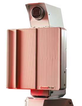
SSR-Omni
The SSR-Omni is a full-coverage, high-resolution monitoring solution that delivers precise, actionable data.
Take a look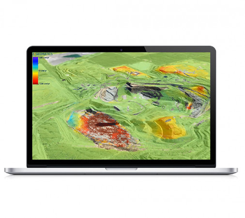
InSAR Service
The GroundProbe InSAR Service, in partnership with 3vGeomatics (3vG), is an effective tool for monitoring and detecting surface movement. It uses satellite-based radars which conduct scans every time they pass over the mine site.
Take a look
SSR-SARx
Designed to identify long-range risks and hazards, the SSR-SARx is a long-range and high-resolution system for the monitoring of tailings dams. The SSR-SARx is a 2D Synthetic Aperture Radar (SAR) designed to detect even the smallest of movements over long periods of time.
Take a look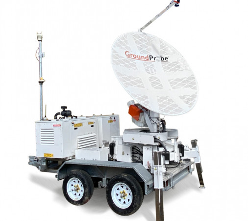
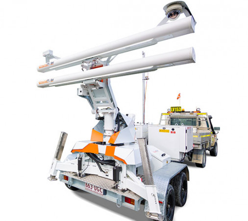
SSR-XT
A tactical and targeted solution, the SSR-XT monitors movement that poses a potential or immediate threat to mine slopes, tailings dams, and surrounding infrastructures in general. The strong precision of its 3D Real Aperture Radar (RAR) ensures that areas of concern are monitored in real-time to ensure safety-critical management of at-risk areas.
Take a lookThe Role of Environmental Compliance Monitoring
The Power of Integrated Geotechnical Monitoring Solutions
Conventional monitoring systems frequently function independently, producing discrete datasets that require a lot of time to analyse. These obstacles are eliminated by GroundProbe’s integrated slope stability monitoring approach, which unifies all monitoring data streams into a single user-friendly platform.
With the help of this integrated monitoring ecosystem, users can:
- Analyse and compare radar, InSAR, and ground-based sensor data side by side.
- Correlate rainfall, deformation, and pore pressure trends for deeper insights.
- Strengthen predictive models through multi-technology data fusion.
- Improve situational awareness with cross-sensor validation and automated alerts.
Challenges of Managing Multi-Sensor Data
With the increasing complexity of contemporary mines and civil projects, the amount and diversity of monitoring data can easily become too much to handle. Teams encounter difficulties like these in the absence of integration:
- Massive, uncorrelated datasets produced by disparate systems are known as data overload.
- Inconsistent Formats: Software and sensors with poor communication capabilities.
- Delays in Decision Making: Time lost combining and analysing disparate data sources.
By combining all geotechnical monitoring systems into a unified interface, GroundProbe’s IMSM solution solves these problems. The process from data collection to actionable insight is streamlined with MonitorIQ®, which allows users to visualise all sensor data, create automated reports, and track trends.
Integrated Geotechnical Monitoring Solutions
GroundProbe provides an extensive selection of multi-technology mine monitoring systems that are intended to cooperate in a variety of site circumstances and risk profiles:
- Sustainable Slope Monitoring: Detects minute ground movements to help maintain slope integrity and prevent erosion.
- GNSS: Provide ongoing positional tracking to confirm geospatial observations.
- InSAR Satellite Monitoring: Provides long-term, wide-area tracking of deformation to complement ground-based radar.
By combining these integrated geotechnical sensors, a comprehensive understanding of both surface and subsurface movement is provided, guaranteeing that no change is missed.
Why Choose GroundProbe?
GroundProbe’s expertise lies not just in developing advanced technologies but in connecting them into one powerful ecosystem. Our global team of geotechnical engineers and technical experts ensures every dataset is accurate, every alert is meaningful, and every decision is informed.
By combining human expertise with world-leading technology, we help operations move from reactive response to proactive, data-driven risk management.
Manage Your Integrated Monitoring with GroundProbe
Want to unify your site’s monitoring data and strengthen decision-making?
GroundProbe’s Integrated Multi-Sensor Monitoring delivers the most complete view of geotechnical performance available, helping you anticipate issues, optimise operations, and improve safety outcomes across your mine or civil project.
Contact GroundProbe today to Integrated Multi-Sensor Monitoring FAQs
What is Integrated Multi-Sensor Monitoring (IMSM)?
Integrated Multi-Sensor Monitoring (IMSM) combines multiple technologies, such as radar, and satellite-based InSAR, into one connected system. By merging these inputs, operators gain a complete view of ground and structural behaviour, allowing faster, more informed decisions that enhance safety and productivity.
Why is a multi-sensor approach important in geotechnical monitoring?
A multi-sensor geotechnical monitoring system provides better accuracy and reliability than individual monitoring systems. The InSAR system tracks long-term deformation patterns while radar technology enables immediate detection of movement. The different monitoring systems provide unique benefits to users. The combination of sensors enhances warning systems and minimises false alarms while verifying sensor data from different sources.
How does MonitorIQ enable integrated monitoring?
MonitorIQ functions as the central control system which collects and shows data from radar and InSAR and ground-based sensors through a unified dashboard interface. The system enables teams to track relationships between data points while analysing patterns and taking immediate action through a unified interface that eliminates platform switching.
Can Integrated Multi-Sensor Monitoring be tailored for different sites?
Yes. The integrated slope stability monitoring systems from GroundProbe operate as fully customisable solutions which adapt to specific site requirements and monitoring requirements. The monitoring system at a mine site uses radar and GNSS for real-time detection and InSAR for long-term tracking of tailings dam movements.
Which industries benefit most from integrated geotechnical monitoring?
IMSM supports industries where stability is critical, including open-pit mining, tailings dams, tunnelling, quarrying, and civil infrastructure. These sectors rely on multi-technology mine monitoring to detect movement early, manage risk, and maintain safe, continuous operations.
What makes GroundProbe’s integrated monitoring unique?
GroundProbe delivers exceptional geotechnical monitoring equipment together with expert engineering support to its customers. MonitorIQ® enables our technologies to work together perfectly while delivering precise verified data, backed by continuous technical assistance. The partnership enables operators to take decisive actions with assurance for protecting people and assets and maintaining operational performance.